Learning the Land: More Than Meets the Eye
As the adage goes, things are not always what they seem. While High Cliff State Park is a lovely place to boat, hike and camp, it holds within it fascinating insights into the forces that govern our planet.
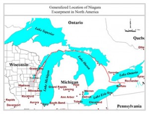
High Cliff is named for the protruding cliff of the Niagara Escarpment. Made of dolostone, a type of limestone containing magnesium, the escarpment extends well beyond the Fox Cities area. As its name might suggest, the Niagara Escarpment forms the cliff that the Niagara River plummets from at Niagara Falls.

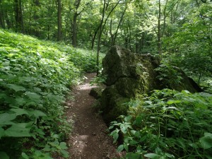
A piece of the cliff lying along the path. This rock was ripped from the cliff by gravity a long time ago.
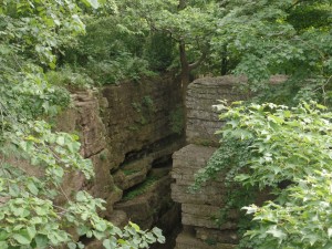
As you walk up towards the cliff at the park, much of the hike is on a dirt path, winding up the hillside. In fact, for most of the walk, the cliff can’t be seen, tucked up behind trees at the top of the long slope. Occasionally, however, you’ll notice large chunks of rock, clearly out of place. After arriving at the cliff, you’ll realize that those chunks were made of the same rock as the cliff itself, pieces of it that had fallen away. Moreover, perhaps the most impressive features of the cliff are the large masses of rock separated from the rest of the formation by distances up to a few yards, seemingly frozen in an ill-fated escape plan.
These oddities are a result of the Niagara Escarpment’s inclusion in the much larger geological formation known as the Michigan Basin. Centered on the lower peninsula of Michigan, for which it’s named, the Michigan Basin consists of nested bowls of rock layers. Typically, rock layers form horizontally, each sheet of rock being laid down on top of each other. In the case of the Basin, this did occur, but then subsequent processes altered the layout. The layers subsided, sinking in at the middle, and creating the bowl-shaped formation we find today.
The cliff is a result of the difference in composition of the Niagara Escarpment layer, the dolostone, and the layer below, a type of shale, or mudstone. Dolostone is tough, and difficult to erode, while mudstone is much easier to work away. This resulted, after millions of years, in the escarpment becoming exposed in the way it is. Think again of nested bowls. If the inner bowl were to be taller than the outer bowl, the inner one will hang out over the other. In a geologic environment, this analogy is expanded to a much more massive scale.

Evidence of the cliff being torn apart. The rock on the right is in the process of falling away as gravity pulls it from the rest of the cliff.
As the mudstone was eroded away, it formed the hill that approaches the cliff, as well as exposing the escarpment, forming the cliff itself. And, as more and more of the mudstone was removed from beneath the dolostone, gravity took effect, pulling bits of the cliff away from the rest, in a process taking thousands to millions of years. In fact, the process is ongoing. As wind and water erode away the mudstone, more and more of the cliff is exposed, and subsequently ripped from the escarpment. Parts of the cliff are in the midst of this process, and will eventually join the pieces strewn down the hill, as the cliff is slowly torn apart.
Beyond High Cliff, the escarpment is best known, in Wisconsin’s case, for creating Door County. As discussed in the previous post, glaciers once covered much of Wisconsin. The Niagara Escarpment runs along the northern edge of the Door Peninsula, and, being tougher than the surrounding rock, kept the glaciers from completely flattening the region.
While places like High Cliff can be great for getting outside and having a good time, they are seldom merely a place for recreation. Learning about the hidden histories of our surroundings can provide a richer understanding of the world around us.
Information from: Roadside Geology of Wisconsin by Robert H. Dott, Jr. and John W. Attig; http://dnr.wi.gov/topic/parks/name/highcliff/.


Leave a Comment